File:Régions de Côte d'Ivoire.png
From Wikimini Coordination Platform
Size of this preview: 216 × 239 pixels. Other resolution: 300 × 332 pixels.
Original file (300 × 332 pixels, file size: 55 KB, MIME type: image/png)
File history
Click on a date/time to view the file as it appeared at that time.
| Date/Time | Thumbnail | Dimensions | User | Comment | |
|---|---|---|---|---|---|
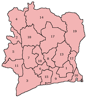
| current | 17:59, 10 June 2010 | | 300 × 332 (55 KB) | Lorangeo | Les 19 régions administratives de la Côte d'Ivoire. 1. Agnéby 2. Bafing 3. Bas-Sassandra 4. Denguélé 5. Dix-Huit Montagnes 6. Fromager 7. Haut-Sassandra 8. Lacs 9. Lagunes 10. Marahoué 11. Moyen-Cavally 12. Moyen-Comoé 13. N'zi-Com |
File usage
The following file is a duplicate of this file (more details):
- File:Régions de Côte d'Ivoire.png from a shared repository
There are no pages that link to this file.