File:Galapagos Islands (map) - Iles Galapagos (carte).png
From Wikimini Coordination Platform

Size of this preview: 240 × 240 pixels. Other resolutions: 600 × 600 pixels | 2,160 × 2,160 pixels.
Original file (2,160 × 2,160 pixels, file size: 1.87 MB, MIME type: image/png)
Summary
| ⧼wm-license-information-description⧽ |
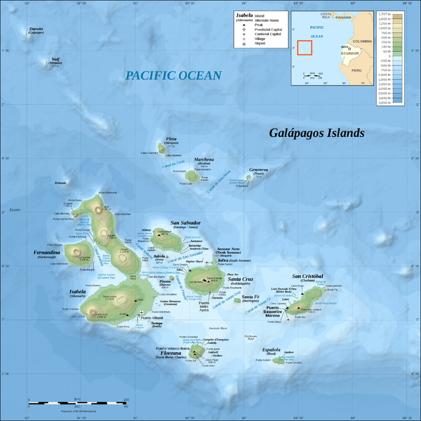
English: Galápagos Islands, Ecuador.
Français : Îles Galápagos Islands, Équateur.
|
| ⧼wm-license-information-source⧽ | https://commons.wikimedia.org/wiki/File:Galapagos_Islands_topographic_map-en.svg |
| ⧼wm-license-information-author⧽ | Eric Gaba |
Licensing
| |
The person who uploaded this file (see below) certifies that he/she has verified the legal terms of use of this image/photo (coypright status) before adding it to Wikimini.
Specifically, use of this image/photo is permitted because it was published under the following free license:
|
File history
Click on a date/time to view the file as it appeared at that time.
| Date/Time | Thumbnail | Dimensions | User | Comment | |
|---|---|---|---|---|---|
| current | 09:01, 3 June 2020 | | 2,160 × 2,160 (1.87 MB) | Lorangeo | {{Information |Description = {{en| Galápagos Islands, Ecuador. }} {{fr| Îles Galápagos Islands, Équateur. }} |Source = https://commons.wikimedia.org/wiki/File:Galapagos_Islands_topographic_map-en.svg |Author = Eric Gaba }} [[Category:Ecuado... |
File usage
The following file is a duplicate of this file (more details):
_-_Iles_Galapagos_(carte).png)
- File:Galapagos Islands (map) - Iles Galapagos (carte).png from a shared repository
_-_Iles_Galapagos_(carte).png)
There are no pages that link to this file.
_-_Iles_Galapagos_(carte).png)
_-_Iles_Galapagos_(carte).png)
_-_Iles_Galapagos_(carte).png&action=edit&redlink=1)
_-_Iles_Galapagos_(carte).png)
_-_Iles_Galapagos_(carte).png&printable=yes)
_-_Iles_Galapagos_(carte).png&action=info)