File:Förstavärldskrigetkarta.png
From Wikimini Coordination Platform
Size of this preview: 320 × 190 pixels. Other resolution: 800 × 475 pixels.
Original file (800 × 475 pixels, file size: 128 KB, MIME type: image/png)
Summary
| ⧼wm-license-information-description⧽ |
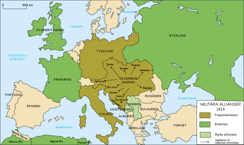
Svenska: första världskriget karta
|
| ⧼wm-license-information-source⧽ | Map_Europe_alliances_1914-en.svg |
| ⧼wm-license-information-author⧽ | Map_Europe_alliances_1914-en.svg |
Licensing
| |
The person who uploaded this file (see below) certifies that he/she has verified the legal terms of use of this image/photo (copyright status) before adding it to Wikimini.
Specifically, use of this image/photo is permitted because it was published under the following free license:
|
File history
Click on a date/time to view the file as it appeared at that time.
| Date/Time | Thumbnail | Dimensions | User | Comment | |
|---|---|---|---|---|---|
| current | 13:27, 14 May 2019 | | 800 × 475 (128 KB) | Jepe49 | {{Information |Description = {{sv| första världskriget karta }} |Source = Map_Europe_alliances_1914-en.svg |Author = Map_Europe_alliances_1914-en.svg }} {{PAGENAME}} |
File usage
The following file is a duplicate of this file (more details):
- File:Förstavärldskrigetkarta.png from a shared repository
There are no pages that link to this file.