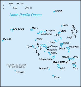
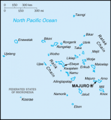
File:Carte des iles Marshall.png
From Wikimini Coordination Platform
Size of this preview: 223 × 240 pixels. Other resolution: 330 × 355 pixels.
Original file (330 × 355 pixels, file size: 7 KB, MIME type: image/png)
File history
Click on a date/time to view the file as it appeared at that time.
| Date/Time | Thumbnail | Dimensions | User | Comment | |
|---|---|---|---|---|---|
| current | 16:23, 2 May 2010 | | 330 × 355 (7 KB) | Lorangeo | Carte des iles Marshall. Source : http://commons.wikimedia.org/wiki/Image:Marshall_islands-map.png?uselang=fr |
File usage
The following file is a duplicate of this file (more details):
- File:Carte des iles Marshall.png from a shared repository
There are no pages that link to this file.