File:Andorra map.png
From Wikimini Coordination Platform
Size of this preview: 223 × 240 pixels. Other resolution: 329 × 354 pixels.
Original file (329 × 354 pixels, file size: 6 KB, MIME type: image/png)
Summary
| ⧼wm-license-information-description⧽ |
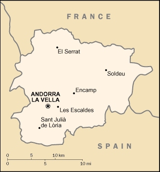
Svenska: En karta över Andorra
|
| ⧼wm-license-information-source⧽ | https://upload.wikimedia.org/wikipedia/commons/1/1d/Andorra_map.png |
| ⧼wm-license-information-author⧽ | By United States Central Intelligence Agency - CIA World Factbook, |
Licensing
| |
The person who uploaded this file (see below) certifies that he/she has verified the legal terms of use of this image/photo (copyright status) before adding it to Wikimini.
Specifically, use of this image/photo is permitted because it is in the public domain, either due to expired copyright or explicit release to the public domain by the copyright holder.
|
File history
Click on a date/time to view the file as it appeared at that time.
| Date/Time | Thumbnail | Dimensions | User | Comment | |
|---|---|---|---|---|---|
| current | 13:54, 20 December 2017 | | 329 × 354 (6 KB) | Theresesilverbage | {{Information |Description = {{sv| En karta över Andorra }} |Source = https://upload.wikimedia.org/wikipedia/commons/1/1d/Andorra_map.png |Author = By United States Central Intelligence Agency - CIA World Factbook, }} [[Category:History_and_geo... |
File usage
The following file is a duplicate of this file (more details):
- File:Andorra map.png from a shared repository
There are no pages that link to this file.